As part of the Reconnecting Communities Pilot (RCP) Program from the US Department of Transportation, the City of Richmond was recently awarded over $9.5 million in order to support a complete streets project in the Iron Triangle, Santa Fe, and Coronado neighborhoods to meet community needs. The funds will be matched with California’s Transformative Climate Communities (TCC) funds. The project will improve connectivity between the community and the shore while enhancing climate resilience and infrastructure.
What Improvements Were Funded?
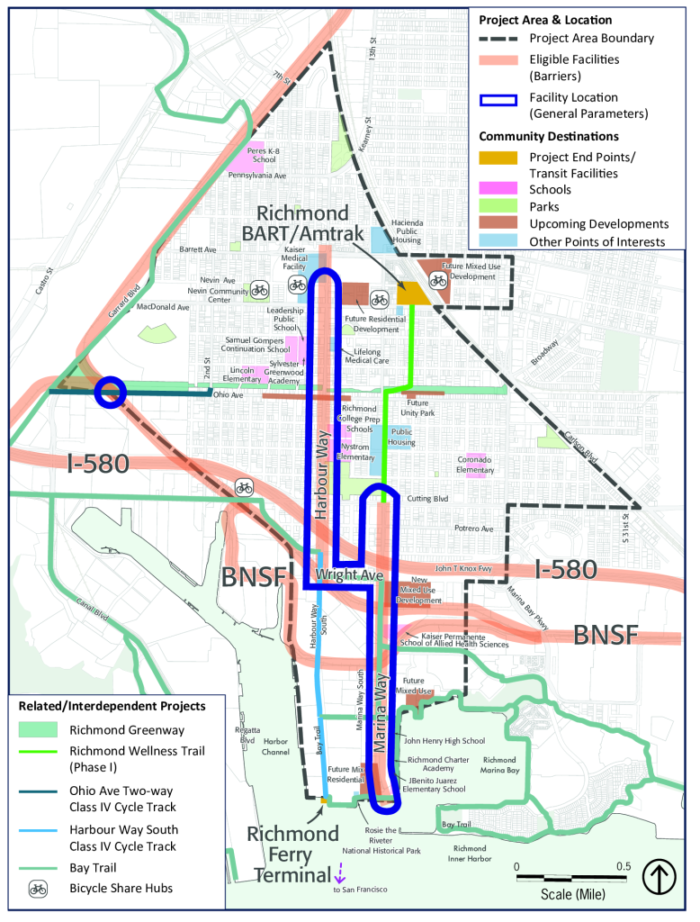
For examples of the bike lane “class” types mentioned in the project summary, see this summary of the California Bikeway Classification System or this video explainer.
Harbour Way – Neighborhood Complete Streets improvements that will include bike lanes, lane reductions, highway crossings, pedestrian crossings, modernizing signals, ADA compliance, and a raised crossing for the Richmond Greenway. Approximately 5,000 feet of Class II bicycle lanes on Harbour Way will link Nevin Avenue and Wright Avenue (south of I-580), including a buffered Class II bicycle lane on the I-580 overcrossing. Entrance ramp striping will be adjusted to improve sight distance between motorists and bicyclists. The intersection of Cutting Boulevard and Harbour Way will see new pedestrian ramps and a median island protecting southbound bicyclists. Seven traffic signals along Harbour Way will be modernized with pedestrian signals, bicycle detection, and ADA-compliant hardware. High-visibility crossings will be added throughout the project. Up to 30 curb ramps will be updated to be ADA-compliant. A raised crosswalk for the Richmond Greenway will improve safety at this vital active transportation corridor.
Marina Way – Improvements will include separated bikeways, modern traffic signals, lane removal, pedestrian lighting, and railroad crossing improvements as part of Phase 2 of the Richmond Wellness Trail. A two-way Class IV cycle track between Cutting Boulevard and Wright Avenue with a new landscaped buffer will separate bicycles from vehicles, with a concrete median on the I-580 overpass, and a one-way cycle track on each side of Marina Way will continue between Wright Avenue and Lucretia Edwards Park (with vehicle lane removal). The final short stretch links to the Bay Trail and will be Class III, as traffic is low. Traffic signals at Cutting Boulevard and at Wright Avenue will facilitate a bike-only phase and improve pedestrian crossings. Two railroad crossings on Marina Way South will receive new signs, strips, paving, and detectable warning devices.
Wright Avenue – Improvements will include adding sidewalks and stormwater infrastructure. Sidewalks will be added on Wright Avenue between Harbour Way and Marina Way on the south side where none exist currently and to expand the small existing segment on the north side to close gaps in pedestrian access between two key active transportation corridors and complete a priority segment of the Bay Trail. Stormwater bioretention areas will be added to reduce runoff and filter rainwater.
Ohio Avenue – The project will complete the crossing of the railroad tracks at Ohio Avenue, just east of the Richmond Parkway, where Ohio Avenue links the Richmond Greenway with the Bay Trail via Second Street. New paving behind the existing railroad gates and installation of new grade-crossing panels, warning lights, bicycle gates, and signage that will improve safety and compliance at this crossing.